The Panorama Route Tours
Top Panorama Route Tours
Full Day Panorama Route Tour – Depart from Hoedspruit
- 1 Day
From ZAR 1995
Full Day Panorama Route Tour – Depart from Hazyview
- 1 Day
From ZAR 1995
4-day Kruger Park and Panorama Route Hotel Safari
- 4 Days
From ZAR 16040
5-day Kruger Park and Panorama Route Hotel Safari
- 5 Days
From ZAR 19680
Full Day Panorama Tour
- 1 Day
From ZAR 2700
History
The Panorama Route Tours in South Africa is a beautiful drive that passes by many historical and natural landmarks. This adventure route lies in Mpumalanga province, near the Blyde River Canyon, the third greatest canyon (and the largest green canyon) in the world.
The Panorama Route in South Africa is a beautiful route that passes by many historical and natural landmarks.
Mpumalanga province, home to the Blyde River Canyon, the world’s third-largest canyon, is where you will find this historically significant path.
There are a number of natural sites, including waterfalls and one of the largest forested areas in South Africa along the route that “officially” begins outside of Lydenburg at the foot of the Long Tom Pass and winds its way down the Great Escarpment and across the Lowveld to the provincial border between Mpumalanga and Limpopo, near the Echo Caves.
This route is profoundly ingrained in South African history. Parts of the route were utilised as a transport road between Lydenburg and Delagoa Bay beginning in 1871.
It is also on this route that General Louis Botha fled from the English during the Anglo-Boer War, and it houses The Long Tom, one of the world’s most famous Victorian-era canons.
Many settlements along the road, such as Pilgrim’s Rest, were founded during the late-nineteenth-century Transvaal gold rush. Thousands of gold seekers traversed the steep mountains and rough terrain in pursuit of riches.
Percy Fitzpatrick, a former Pilgrim’s Rest storekeeper, was one of them. He wrote the iconic book Jock of the Bushveld, which recounted some of his adventures while travelling this famous path with his beloved bull terrier Jock.
Sightseeing on the Panorama Route
Among the many natural attractions found here are numerous waterfalls and one of the largest forested regions in South Africa. Depending on how you view it, the Panorama Route includes the following drives:
One route begins in Nelspruit, where the Lowveld Botanical Garden can be visited. It then travels to White River, where you can visit a motor museum. With activities like 4×4 trips and abseiling, Sabie provides plenty of adventure. Pilgrims Rest has a few spectacular pubs and restaurants that are a must-see if you want to experience the town’s culture.
With attractions such as God’s Window, Lisbon Waterfalls, Berlin Falls, and Bourke’s Luck Potholes, Graskop can be seen as the highlight of the Panorama Route.
This route concludes at the Blyde River Canyon with the Swadini Forever Resort, which offers a variety of activities ranging from boat rides to Microlight battles.
Alternatively, a route begins outside Lydenburg at the base of Long Tom Pass, winds its way down the Great Escarpment and into the Lowveld, and ends close to the provincial border between Mpumalanga and Limpopo, not far from the Echo Caves.
On the Panorama Route you will find:
Gods Window
At the famous Gods Window, the steep walls of a deep gorge frame the view of the escarpment forest. From this “window,” a paved path along the escarpment leads to Quartzkop and the Rain Forest, which has a natural garden under a tree canopy and brightly coloured aloes in the winter.
All of this is separated by outcrops of sandstone that have been worn down into strange prehistoric shapes.
Through the rain forest at God’s Window, there is a path that leads to Wonderview. At 1 750m above sea level, the walk gives you beautiful views of the Lowveld, with its forested area in the foreground, the Kruger National Park in the background, and the Lebombo mountains, which are the natural border between South Africa and Mozambique, in the far distance.
Lisbon Falls
The Lisbon Falls are situated just north of Graskop along the R532 road.
The falls in the Lisbon Creek, a right bank tributary of the Blyde River, were named after the capital of Portugal, Lisbon, to commemorate that some of the people who came to the area to mine gold in the late 1800s were from Portugal. The water falls 95 metres in a triple cascade into a pool at the bottom and are the highest waterfalls in Mpumalanga.
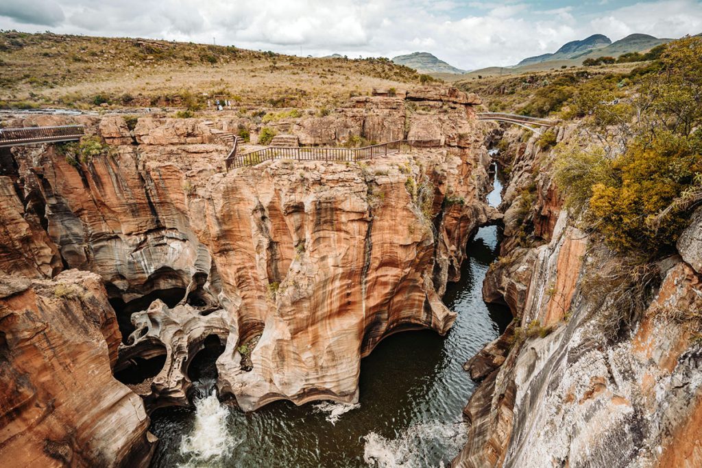
Bourke’s Luck Potholes
One of the most interesting geological things on the Panorama Route is where the Treur and Blyde rivers meet. At the point where the two rivers meet, there are swirling whirlpools that have been formed over countless millennia. Sand and rocks carried by the water have worn deep cylindrical potholes into the bedrock over time.
At the Visitors Centre, you can see some of the interesting natural and social history of the reserve. The Blyde River Canyon also starts at the Potholes.
Pinnacle Rock
This is a tall column of weathered quartzite with lots of colourful aloes growing on it. It is 30m taller than the native forest in the Driekop Gorge, which is situated all around it. This is also the source of the Ngwaritsana River, which flows through the narrow cleft on the right at the top of the gorge.
Berlin Falls
A single stream of water drops 45 metres into a pool at the bottom of this waterfall, which is named after the farm where it is located. At the top of the falls, where there are great views, there is a path that people use to cross the falls. This area is typical of the early days (the second half of the 19th century), when people looking for their fortunes panned the streams for alluvial gold.
The R532 will take you from the Berlin Falls through thick Pine and Eucalyptus plantations. About 33 km from Graskop, the road connects to the Treur River and the southern end of the Blyde River Canyon. During the summer, orange and yellow lichen cover the amazing rock formations and waterfalls, which are most impressive when the sun is shining in the afternoon.
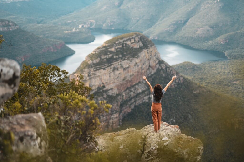
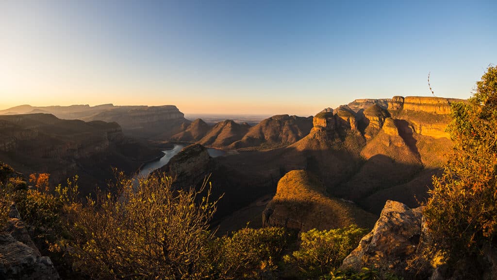
Blyde River Canyon
It is said to be the third largest canyon in the world, after the Grand Canyon in Nevada, USA, and the Fish River Canyon in Namibia and boasts some of the most dramatic and overwhelming scenery in the country. Unlike the Grand and Fish River Canyon, the Blyde River Canyon is a “green canyon” and dominated by subtropical vegetation.
The canyon forms part of the Blyde River Canyon Nature Reserve (also officially known as Motlatse Canyon Provincial Nature Reserve), which covers about 30 000 hectares. The 57-kilometer nature reserve belt starts at Graskop and goes along the edge of the escarpment.
Because the southern section is high and gets a lot of rain (about 3 000 mm per year at God’s Window), the route goes through a lot of grasslands and natural rain forests.
The Lowveld View site
This viewpoint is situated between Bourke’s Luck Potholes and The Three Rondawels on the R532 and provides the best panoramic view of the Blyde River Canyon, The Blydepoort Dam and the Lowveld beyond.
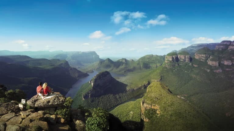
The Three Rondawels
These rock formations, which used to be called the Three Sisters, are one of the many natural sights that stand out on Mpumalanga’s Panorama Route.
Also, it used to be called after three of Chief Maripi Mahile’s many wives. Magabolle, which is 1 354m above sea level, is on the left. Mogoladikwe is 1 377 metres above sea level and Maseroto is 1 465 metres above sea level.
The name ‘Rondawel’ also signifies their similarity to the traditional beehive-shaped huts that indigenous people have built and lived in for hundreds of years.
You might also like Blyde River Canyon Tours or Best Kruger Park Day Tours.
Historical and Cultural Sites Along the Route
The Panorama Route is home to various notable cultural and historical attractions due to the area’s long history. These are some examples:
Shangana Cultural community near Hazyview is a traditional community that honours the Shangana people.
The Lydenburg Museum displays exhibits of the area’s early human residents, the most notable of which being the Lydenburg Heads. A small kid discovered unusual shards of pottery eroding out of a gully in Lydenburg, Mpumalanga, South Africa, between 1962 and 1964. Although the fragments were not properly excavated, the majority of them were discovered and reassembled to form seven clay heads known as the Lydenburg Heads.
The museum also provides visitors with an overview of the Pedi people’s anthropological past.
Joubert Bridge is one of the area’s oldest bridges. It was constructed to span the Blyde River and connect Pilgrim’s Rest with Lydenburg. The bridge was designed by Italian engineer Giovan B Gilletti and was opened in 1897 by Pilgrim’s Rest mine commissioner Jacobus Stephanus Joubert.
Towns Along the Panorama Route
Lydenburg
Andries Potgieter, a Voortrekker leader, built this historic town in 1850. It was the capital of the Zuid-Afrikaansche Republiek for a short time.
The Lydenburg Heads, 500-year-old hollow clay sculptures on display at the Lydenburg Museum indicate that an unknown culture colonised the region long before this as these people are believed to have utilised the statues in religious events.
The discovery of alluvial gold in 1873 triggered a brief gold rush in the town. The village was also on the way from the Transvaal Republic to Delagoa Bay. Lydenburg is now recognised for its farming, trout fishing, and mining. The Panorama Route begins immediately outside of Lydenburg, near the Long Tom Pass.
Sabie
Sabie is well-known as a forestry and tourist destination.
The Sesotho lived in the town in the early 1800s but after the discovery of gold in the area in 1873, Europeans began to settle in the town.
Because of its high elevation, it was utilised as a base for early big game hunters because it was malaria-free and due to the river (also known as the Sabie river) frequently overflowing and infested with crocodiles, the locals dubbed it uluSaba – the river of terror.
Much of the natural forests in the area were cleared to supply wood for the mining industry, and since 1876 commercial trees were planted in, leading to Sabie being surrounded by one of the largest man-made forests in the world.
Graskop
The town of Graskop dates back to 1837, when Voortrekker leader Andries Pretorius and his followers were looking for greener pastures. In his memoirs, he told about leaving women behind in Graskop (translated as “grassy hill”) while searching for an ox waggon passage to Delagoa Bay.
Today, Graskop is mostly a tourist town near various natural wonders such as God’s Window and Bourke’s Luck Potholes.
Pilgrim’s Rest
Pilgrim’s Rest is around 35 kilometres north of Sabie.
The entire town is a national monument, a restored gold-mining village with curio stores and Victorian architecture.
Its history begins in 1873, when Alex Patterson discovered alluvial gold. It quickly became known as a community for fortune seekers, with around 1500 “diggers” joining Patterson within a year.
Later, Transvaal Gold Mining Estates became South Africa’s first publicly traded gold mining corporation.
Annually, the town hosts the National Gold Panning Championships, and visitors can also book a panning excursion.
Hazyview
Hazyview is a small village that serves as an important gateway to the Kruger National Park’s Phabeni Gate. Hazyview is well-known for its animal sanctuaries, including a world-renowned elephant sanctuary.
According to legend, a French-Canadian named Perry landed in the area while fleeing an alleged murder conviction. He started a trading store, but following his death, the property was sold and one of South Africa’s first private wildlife reserves was established on the area.
Tourism, agriculture (particularly banana growing), and retail drive the economy of this town.
Ohrigstad
Ohrigstad is a small settlement on the border between Mpumalanga and Limpopo. The town was named after Voortrekker leader Andries Hendrik Potgieter and G. G. Ohrig, an Amsterdam trader who desired to foster trade between the Netherlands and the Zuid-Afrikaansche Republiek.
There are now various game farms and commercial crops around the town. The well-known Echo Caves are located around 28 kilometres north of town.
Mountain Passes Along the Panorama Route
Mpumalanga and Limpopo are known for their beautiful mountain ranges. The Drakensberg is a portion of the Great Escarpment that separates South Africa’s huge high plateaus from the lower plains along the coast.
The range runs from Limpopo and Mpumalanga provinces in the northeast to Lesotho province in the east.
Driving along the Panorama Route, you may drive over several scenic mountain passes, including:
- Long Tom Pass between Lydenburg and Sabie
- Bergvliet Pass between Sabie and Hazyview
- Blyderiver Poort Pass between Graskop and Ohrigstad
- Bonnet Pass between Graskop and Pilgrim’s Rest
- Kiepersol Pass between Sabie and Kiepersol
- Robber’s Pass between Pilgrim’s Rest and Ohrigstad
- Sudwala Pass between Lydenburg and Sudwala Caves
Frequently Asked Questions
What are the most popular sights on the Panorama Route tour?
Some of the most popular sights on the Panorama Route tour include the Blyde River Canyon, the Three Rondavels, and God’s Window.
How long does it take to tour the entire Panorama Route?
The entire tour drive along the Panorama Route can take anywhere from half a day to a full day depending on the time taken for stop-overs, lunches etc. If a sleep-over is included in your tour itenary it can take more or less 1 and a half – two days.
What is the best time of year to tour the Panorama Route?
The best time to tour the Panorama Route is during the dry season, from April to September, when the weather is more pleasant and the views are clearer.
Are there any guided tours available on the Panorama Route?
Yes, there are several guided tours available that take visitors on the Panorama Route and provide more in-depth information about the sights along the way.