#1 Namibia Safaris
Our Top Selling Tour
From Victoria Falls Airport
4 Day Namib Coast & Sossusvlei Adventure Tour
You travel from Windhoek to Swakopmund on the Skeleton Coast and Sossusvlei in the Namib-Naukluft National Park.
Swakopmund is the outdoor playground of Namibia while Sossusvlei is a magical destination that falls within the largest conservation area in Africa. Breathtaking scenery, abstract natural wonders and the warm-hearted people of Namibia make this a once-in-a-life time tour for wanderlust travellers.
Trending Tours
4 Day Etosha & Namib Coast Adventure Tour
The 3 night/4 day Etosha & Namib Coast Adventure Tour offers guests a glimpse of the wonders of the vast wilderness area...
From ZAR 13590
7 Day Namibia Highlights Adventure Tour
The 6 night/7 day Namibia Highlights Adventure Tour takes you on a fascinating journey through vast windswept arid plains...
From ZAR 27590
Half Day Sandwich Harbour and Desert Tour
Namibia is one of the most popular 4×4 destinations in southern Africa. Your guide will skillfully navigate the desert...
From ZAR 1800
Half Day Sandwich Harbour and Desert Tour
- < 4 Hours
From
7 Day Namibia Highlights Adventure Tour
- 7 Days
From
4 Day Namib Coast & Sossusvlei Adventure Tour
- 4 Days
From
4 Day Etosha & Namib Coast Adventure Tour
- 4 Days
From
Self Drive Namibia safaris
13 Day Namibia Highlights Self-Drive Safari
- 13 Days
From
12 Day Namibia Highlights Self-Drive Safari
- 12 Days
From
11 Day Namibia Highlights Self-Drive Safari
- 11 Days
From
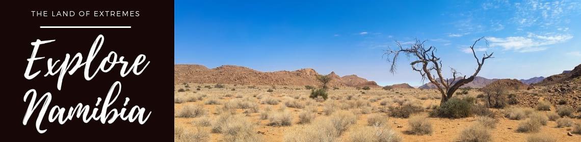
Namibia is a land of extremes; from the ghostly plains of the coastal belt to the strikingly beautiful arid sand dunes in central Namibia and the lush, subtropical floodplains in the north. Most tourists start a tour or safari of Namibia on the treacherous coast of Namibia which lies on the cold Atlantic coast. The coastal belt is renowned for being a desolate and inhospitable place; with the Namib Desert emptying into the icy ocean, leaving behind incredible species of plants and animals that have adapted to the hostile desert conditions. Moafrika offers the best of Namibia in offering guided Namibia safaris and tours for the budget or luxury traveler. View all packages and prices.
The northern region of Namibia experiences higher rainfall and places like Etosha and the Caprivi Strip transform into a magical oasis when the rains fall. An abundance of migratory birds and wildlife descend on the area, with predators in hot pursuit.
Namibia shares its northern border with Zambia and Angola, with Botswana to the east and South Africa to the south and east. At a small bulge on the Zambezi River (a micro-border dividing Botswana and Zambia), one can cross over into Zimbabwe; a mere 200 meters separating the two countries.
The country is vast and is one of the most sparsely populated in the world. The majority of tourists visiting Namibia chose to travel with a tour operator that is experienced in the delights and dangers of such a mystical place. Moafrika Tours offers tourists a once-in-a-lifetime experience; to criss-cross, the mighty rivers of Namibia, find out more about the desert-dwelling animals that have made the dry land their own and discover the warmth and hospitality of its people.
MoAfrika Tours also offer an array of incredible tours to iconic places in South Africa, like the Johannesburg tour, Soweto tour, Kruger safari tours, and the world-renowned Cape Winelands tour. You can also combine some of these places with one of our South Africa Tours.
MOST POPULAR PLACES TO VISIT IN NAMIBIA WHILE ON A NAMIBIA SAFARI
A tour of Namibia in a rugged 4×4 vehicle usually involves traveling long distances between destinations; crisscrossing endless stretches of arid thirstlands and the country’s mighty rivers to arrive at dusty towns steeped in rich history. For those on a tight schedule, Namibia has an excellent state-owned airline or you can choose to use the services of a private airline operator.
MoAfrika Tours has selected a few of its favourite destinations in Namibia with a few located off the beaten path. If you don’t have time to visit the many major safari attractions in Namibia, we know you’ll be back for more.
Etosha National Park
Etosha National Park is the wilderness gateway to northern Namibia and Ovanboland. The name Etosha means the “great white area” and refers to the expansive arid pan in the middle of the Park. The Park was proclaimed a protected wildlife sanctuary in 1907 and elevated to the status of National Park in 1967. Over decades it has grown in reputation as one of the world’s best tourist destinations in Namibia.
The landscape of this magical wilderness is dominated by a salt pan that spans some 22 000 square kilometers, covering 25% of the total area. It is 130 kilometers long and up to 50 kilometers wide in places, making it the largest salt pan in Africa. It is so large that it can be seen from space.
Etosha National Park is world-renowned as a premier safari destination. Apart from the incredible sightings of wildlife, it is a birder’s paradise and heaven for photographers. The diverse biosphere makes it one of the most interesting places to visit in Namibia. It is home to hundreds of species of mammals, migratory birds, and reptiles including many endangered and endemic species not found anywhere else in Africa.
Etosha Pan was once an ancient inland lake formed over 100 million years ago. Due to tectonic forces and climate change, the rivers that once fed the lake were forced to change course and emptied instead into the Atlantic Ocean. The inland lake dried up leaving behind a shimmering surface of glittering salt. The only clue that it was once a lake lie deep underground as baked alkaline clay marks.
There is very little vegetation of much nutritional value around the salt pan but in the wet season, the area transforms into a magical oasis which attracts an abundance of game, birds and, of course, safari tourists. Etosha is the only known breeding ground for flamingos in Namibia and the sight of more than a million flamingos settled on the vast pan is breath-taking.
You might also like our Botswana Safaris. At MoAfrika we have a wide selection of tours and safaris all over South Africa as well as destinations in Africa. Don’t miss out on our affordable 2024/2025 holiday packages.
NamibRand Nature Reserve
NamibRand is one of southern Africa’s largest private nature reserves built on the vision of one man who dreamt of extending the desert frontiers with the cooperation of a large number of local sheep farmers. He dreamt of a reserve that allowed the precious wildlife of Namibia to roam freely, unhindered by fences and restricted to habitats.
JA Brückner fulfilled his life’s ambition, founding NamibRand Nature Reserve in 1984 and developing it into one of Africa’s premier wildlife sanctuaries. To date, seventeen former livestock farms have been rehabilitated into a single continuous natural habitat. At least 15% of the total area has been exclusively set aside for the protection and conservation of wildlife, birds and its unique biosphere.
NamibRand is characterised by four distinct habitats; dunes and sandy plains, inselbergs (small hills) and mountains, true gravel plains and a combination of sand and gravel plains. It is home to endemic species like the Oryx gazelle (gemsbok) and springbok. An abundance of antelope make it a predator’s paradise with kudu, Hartman, the Burchell’s zebra, giraffe, klipspringer, steenbok, hartebeest and baboon creating a smorgasbord of delights for the big cats as well as spotted and brown hyena, black-backed jackal, aardwolf, bat-eared fox, African wild cat, caracal and genet.
Ornithologists have identified more than 150 bird species in the reserve, either endemic to the area or migratory species. The compilation of the list of reptiles, amphibians, invertebrates, and plants is ongoing and endless.
Apart from its significant role in protecting the birds, wildlife, and biosphere of the eastern edge of the Namib Desert, the reserve has played a critical role in facilitating seasonal migratory routes. Large herds of elephants and wildebeest roam freely between the reserve, its neighbour Namib-Naukluft National Park and the imposing Nubib Mountains.
A visit to NamibRand offers those on a Namibian safari a small glimpse of the incredible delights of the natural wonders of Namibia. The reserve is registered as a non-profit private reserve and is financially self-sustaining through high quality, low impact tourism.
Dead Vlei in Sossusvlei
Dead Vlei is a popular safari destination located near the famous salt pan of Sossusvlei, inside the Namib-Naukluft Park. The name means “dead marsh” although this is misleading as the Sossusvlei and surrounds is recognised for its abundance of desert-dwelling wildlife and small creatures that have adapted in the most incredible ways to survive in the hostile arid environment.
The clay pan is a photographer’s dream destination and instantly recognised in the hundreds of images found on the internet. It is characterised by dark, dead camel thorn trees that stand out in stark contrast to the white pan floor.
The pan was formed when the Tsauchab River flooded and the abundance of water created a fertile environment to support the desert trees. Climate change and encroaching sand dunes blocked the river centuries ago, preventing the water from reaching the area. The trees did not decompose due to the dry climate but stand sentry in the rusty-red dunes, appearing as burnt-out relics of ancient times. Some of the trees are estimated to be over 900-years old.
There are a few remaining plant species that have survived since the area was once a lush floodplain. These include the salsola and clumps of nara which sustains themselves on precipitation from the morning dew and very rare rainfall.
Dead Vlei is surrounded by the highest sand dunes in the world. One, affectionately named Big Daddy, stands about 300-400 meters off the sandstone terrace floor. Dune 45 in Sossusvlei is one of the most photographed dunes in the world. A climb to the top is exhausting but worth every drop of sweat. The view from the top is breathtaking.
Skeleton Coast National Park
The entire coastline of Namibia is often mistakenly referred to as the Skeleton Coast. However, the formal area known as the Skeleton Coast National Park is a strip of coastal land extending from the Kunene River in the north for approximately 500 kilometers to the Ugab River. The reserve was established to protect one-third of Namibia’s coastline but the name has been applied to the entire length of its western border purely because it so aptly describes the hostile and somewhat spooky coastline.
The Kunene River is one of Namibia’s few perennial rivers, rising in the remote Angola highlands and forming one of the country’s two permanent estuaries. The bleak and inhospitable eco-zone is home only to a select few desert-dwelling animals, reptiles and amphibians who have adapted in the most incredible ways to survive extended periods of scorching heat, vicious wind or icy conditions.
The arid landscape is dominated by massive sand dunes that move constantly at a painstaking pace as well as magnificent desert canyons and mountain ranges. Dense fog and cold sea breezes roll in from the sea off the icy Benguela current. These icy winds clash with the extreme heat of the Namib Desert creating a biosphere so unique it is breath-taking.
The Skeleton Coast has long been associated with famous shipwrecks and is known as the largest “ship graveyard” in the world. The name itself came from bones scattered the length of the coastline; a sad tale of whaling and seal hunts and human explorations that went wrong. The Bushmen called it “The land God made in anger” and the Portuguese explorers called it “The gates of hell”. Blinding fog, treacherous seas and unrelenting surf took their toll on many ships and their unfortunate crew.
Despite its stark and deadly appearance, the Skeleton Coast National Park is world-renowned as one of the best places to visit to kick-off a Namibia safari tour. Namibia’s famous desert-dwelling elephants, black rhino, lion, cheetah, giraffe, gemsbok, zebra, springbok and spotted and brown hyena are sought-after sightings. A knowledgeable safari guide will show you other quirky desert creatures, snakes and plant life that are fascinating, like the endemic Gerrhosaurus skoogi which is an armor-plated lizard that prowls the sand dunes in search of Nara melon bushes.
The mouth of the Kunene River is the southern-most breeding territory of the green turtle and home to the only southern African population of Nile soft-shelled turtles. They may look cute but be warned; they are aggressive.
More than 250 species of birds have been recorded in the Skeleton Coast National Park, including the endemic Damara Tern. Fishing off the Skeleton Coast is spectacular as well as sightings of the endemic Benguela dolphin, killer whales, and humpback whales. On rare occasions, sightings of lions create a stir as they scour the beach for marine carrion.
The delights of the Skeleton Coast National Park don’t only revolve around spectacular scenery and fascinating wildlife. Incredible geological features dominate the area, including gemstone beaches, salt/brine pans and shifting sand dunes. Möwe Bay is well-known for its rainbow carpet of semi-precious stones, some of which are found embedded in the scattered remains of whale skeletons and amongst shipwrecks that met their brutal end some 500 years ago.
Fish River Canyon
The Fish River Canyon is located in southern Namibia and is the largest canyon in Africa. It is one of the most popular tourist destinations in Namibia, particularly with hikers and outdoor enthusiasts.
The enormous ravine stretches some 160 kilometers into the Namib Desert, up to 27 kilometers wide and 550 meters deep in some places. The Fish River cuts deep into the arid, stony canyon floor, only flowing in late summer at the end of the rainfall season. For the rest of the year, the river is a long chain of narrow pools flanked by dusty riverbeds with a smattering of hardy drought-resistant plants.
The main attraction of the canyon is a hot springs resort at the lower end of the gorge. Ai-Ais Hot Springs and its campsite falls within the Ai-Ais/Richtersveld Transfrontier Park. This area is accessible to the public but the remaining 90 kilometers of the canyon are owned by private concessions.
The Fish River Canyon is characterised by two biospheres; the upper canyon is dominated by hard gneiss bedrocks which have been uncovered by soil erosion, and the lower canyon which formed when erosion finally wore down the gneisses outcrops. Over centuries, erosion created a deep ravine with a narrow meandering network of streambeds that wind and twist their way to the end of the canyon.
Hiking trails in the canyon are extremely popular. The immense scale and rugged terrain attracts extreme trail runners as well as hikers who are happy to tackle the canyon at a more leisurely pace. The 88-kilometer trail ends at Ai-Ais hot springs and it usually takes about 5 days to get there. There are no campsite or amenities on the trail and hikers need to carry everything they need in their backpacks. Hikers sleep under the stars which is no problem in the hiking season as the nights are usually mild and pleasant.
Due to seasonal flooding and scorching summer temperatures, hikers need to obtain permits to visit the canyon between May and September. Hikers must be older than 12 years and older hikers need to submit a certificate of fitness issued by a doctor. You are hiking in hostile terrain and these precautions must be respected for the well-being of the group.
MoAfrika Tours can arrange bus tours and transfers from Pretoria, Johannesburg, Durban, Port Elizabeth and Cape Town. Contact us to help you plan your travel itinerary that will suit your budget to any destination in South Africa. As well as tours and safaris to Botswana, Namibia, Victoria Falls & Uganda.
Bwabwata National Park in the Caprivi Strip
Bwabwata National Park is a community-driving initiative located in north-east Namibia. It was established in 2007 in the Caprivi Game Park and Mahango Game Reserve and spans some 6 300 square kilometers. Its boundary is the magnificent Okavango River to the west and the Kwando River to the east. Angola lies to the north and Botswana to the south.
The region falls within the Caprivi Strip along an important migration route from Botswana to Angola. Large herds of elephants, as well as wildebeest and other antelopes, have roamed these wilderness paths for centuries. What makes the reserve unusual is that it is the only national park in Namibia where the government has allowed local inhabitants to live in a protected area and manage its natural resources.
Bwabwata National Park is dominated by shrub savanna and woodlands, including north-eastern Kalahari, Caprivi mopane, riverine and islands, Okavango Valley and Caprivi floodplain woodlands. The vegetation is sparse but it sustains an abundance of wildlife and birds in the wet season, mainly due to it being a critical trans-boundary link for wildlife moving freely between Angola, Botswana, Namibia and Zambia.
The region is regarded as a birder’s paradise being home to rare and endangered species like the black-winged pratincole, slaty egret, wattled crane, African skimmer and African pygmy-goose to mention just a few. An abundance of antelope in the rainy season attracts the Katanga lion, African leopard, South African cheetah and spotted hyena.
Spitzkoppe
Spitzkoppe is a fascinating tourist destination in Namibia, more popular with geologists, rock climbers and stargazers. Meaning “pointed dome” in German, Spitzkoppe is a group of bald granite peaks or inselbergs (small hills) that have been dated to more than 120 million years old. The rocky outcrop is located between Usakos and Swakopmund and is a hive of activity in the vast desolate Namib Desert.
The highest granite outcrop rises about 1 784 meters above sea level and some 700 meters off the desert floor. Other prominent granite features stretch out into a range known as the Pontok Mountains. It’s affectionately known as the Bushmen’s natural art gallery as many examples of rock paintings are found in the Spitzkoppe area.
Geologists refer to it as the “Matterhorn of Namibia” and estimate the rocky region to be nearly 700 million years old. Apart from the privilege of rock hopping over some of the oldest rocks accessible to man, a visit to Spitzkoppe takes you place of deep solitude with evenings spent contemplating the wonders of life under a blanket of glistening stars.
Twyfeltontein
Twyfelfontein is located in the breath-taking belt in the Huab valley which is located in the Hunene region (formerly known as Damaraland). Known as the Twyfelfontein Uibasen Conservancy, it is world-renowned for its collection of ancient rock engravings and paintings created by the first hunter-gatherer tribes some 6 000 years ago.
The Khoi-San inhabitants regarded it as a place of worship and performed shaman rituals which have been captured in a silent form in 17 different rock painting sites on about 212 stone slabs.
Its unusual name was given by a farmer who settled in the area in 1946. He named it Twyfelfteing (meaning uncertain or doubtful spring in Afrikaans) as he was not sure whether the natural spring would provide him with enough water.
The ancient rock art gallery and surrounds were proclaimed a national monument in 1952. To preserve its unique history and cultural heritage, it was proclaimed a UNESCO World Heritage Site in 2007. The Khoi-San people no longer live in the area but the site plays an important role in understanding the fascinating belief system and way of life of their ancestors who first settled in the area over 1 000 years ago.
Cape Cross
Cape Cross is a small headland jutting out into the South Atlantic Ocean on the Skeleton Coast. It is home to the largest colony of Cape Fur seals in the world and is a protected area owned by the government of Namibia.
The Cape Cross Seal Reserve is strictly managed to safeguard the seal colonies and the economic impact they have on the fishing industry. It is one of only two sites in Namibia (the other is Lüderitz) where the Cape Fur seals are culled. Their hides are sold as part of a community-based initiative to supplement the local fishermen’s livelihoods. Protection of the colony by the government is essential as they were under threat of extermination by fisherman that regard them as pests.
Cape Cross was named after the original padrão (stone cross) that was erected to honor the bravery of Portuguese explorers who discovered the headland while searching for a sea route to India and the Spice Islands. Two replicas now stand at Cape Cross in the place of the original stone cross that was destroyed over time by wind and sand.
Brandberg
The Brandberg (Damara: Dâures; Otjiherero: Omukuruvaro) is Namibia’s highest mountain.
Brandberg Mountain is located in former Damaraland, now Erongo, in the northwestern Namib Desert, near the coast, and covers an area of approximately 650 km².[3] With its highest point, the Königstein (German for ‘King’s Stone’), standing at 2,573 m (8,442 ft)[1] above sea level and located on the flat Namib gravel plains, on a clear day ‘The Brandberg’ can be seen from a great distance. There are various routes to the summit, the easiest (also steepest) being up to the Ga’aseb river valley, but other routes include the Hungurob and Tsisab river valleys. The nearest settlement is Uis, roughly 30 km from the mountain.
Origin of name
The name Brandberg is Afrikaans, Dutch and German for Fire Mountain, which comes from its glowing color which is sometimes seen in the setting sun. The Damara name for the mountain is Dâures, which means ‘burning mountain’, while the Herero name, Omukuruvaro means ‘mountain of the Gods’.
Geology
The Brandberg Massif or Brandberg Intrusion is a granitic intrusion, which forms a dome-shaped massif. It originated during Early Cretaceous rifting that led to the opening of the South Atlantic Ocean. Argon–argon dating yielded intrusive ages of 132 to 130 Ma.[4] The dominant plutonic rock is a homogeneous medium grained biotite-hornblende granite. In the western interior of the massif (Naib gorge), a 2 km in diameter body of pyroxene-bearing monzonite is exposed. The youngest intrusive rocks based on cross-cutting relations are arfvedsonite granite dikes and sills in the southwestern periphery of the Brandberg massif which crop out in the Amis valley. The arfvedsonite granites contain minerals rich in rare earth element minerals such as pyrochlore and bastnaesite. Remnants of Cretaceous volcanic rocks are preserved in a collar along the western and southern margins of the massif. Their angle of dip increases towards the contact where clasts of country-rock occur within the granite forming a magmatic breccia. The origins of the magmas that formed the Brandberg intrusion are related to emplacement of mantle-derived basaltic magma during continental break-up which led to partial melting of crustal rocks resulting in a hybrid granitic magma. Erosion subsequently removed the overburden rock. Apatite fission track dating indicates approximately 5 km denudation between 80 and 60 Ma.[5]
An associated feature is the Doros Complex.
Rock painting
Planning a last minute breakaway for 2 or for your family? MoAfrika offers a wide selection of romantic packages and family packages. Enquire now about our 2024/2025 rates and availability for our holiday packages.
White Lady, Brandberg, Namibia
The Brandberg is a spiritual site of great significance to the San (Bushman) tribes. The main tourist attraction is The White Lady rock painting, located on a rock face with other art work, under a small rock overhang, in the Tsisab Ravine at the foot of the mountain. The ravine contains more than 1 000 rock shelters, as well as more than 45 000 rock paintings.[6]
To reach The White Lady it is necessary to hike for about 40 minutes over rough terrain, along with the ancient watercourses threading through the mountain.
The higher elevations of the mountain contain hundreds of further rock paintings, most of which have been painstakingly documented by Harald Pager, who made tens of thousands of hand copies. Pager’s work was posthumously published by the Heinrich Bart Institute, in the six-volume series “Rock Paintings of the Upper Brandberg” edited by Tilman Lenssen-Erz. (I. Amis Gorge, II. Hungorob Gorge, III. Southern Gorges (Ga’aseb & Orabes), IV. Umuab & Karoab Gorges, V. Naib (A)and the Northwest, VI. Naib (B), Circus & Dom Gorges. Volume VII. Numas Gorge is unlikely to be published due to discontinued funding.)
Wildlife
The Brandberg is also home to some interesting desert flora. Damaraland is well known for its grotesque aloes and euphorbias and the region around the mountain is no exception. The area has many plants and trees that have an alien appearance, due in part to the extreme climatic conditions.
The area is uninhabited and wild. It is very arid and finding water can be difficult or impossible. In summer temperatures over 40 °C are routine.
Nonetheless, the Brandberg area is home to a large diversity of wildlife. The numbers of animals are small because the environment cannot support large populations, however, most of the desert species that are found in Namibia are present and visitors to the area might glimpse a desert-dwelling elephant or a rare black rhino.
Swakopmund Museum
The Swakopmund Museum
The Swakopmund Museum was founded in 1951 by dentist Dr. Alfons Weber. It is the largest privately run museum in Namibia. On display are various types of indigenous plants, animals, minerals, an archaeological exhibition, the transport system of old and a variety of cultural-historical objects. One of a kind and educational is the exhibition “People of Namibia.” This focuses on the traditional heritage of the different ethnic groups of Namibia. HERE you will find an overview of the exhibits of the Museum.
The museum shop has a large variety of competitively priced books, postcards and souvenirs. You can even send your post from here!
Interesting local videos are shown at the Swakopmund Museum upon request between 11:00 and 13:00. We have new informative videos available. Apart from the German video about Swakopmund (Swakopmund 1892-1915 by Immo Böhlke) we show the interesting film “South West Africa in Pre-colonial days” and the natural history films: “The Namib Desert Coast”, “The Dorob National Park – a beauty once lost can never be regained” and “Ecotourism and Namibia’s wetlands: Supporting livelihoods”.
Epupa Falls
The Epupa Falls sits on the Kunene River on the border of Angola and Namibia in an area commonly known as Kaokoland. They are created by a series of cascades that drop a total of 60m over a distance of about 1.5km. At one point it reaches a total width of about 500m. This feature is also known as Monte Negro Falls in Angola. The name Epupa is a Herero word for the plumes of spray created by falling water.
Epupa Falls are not to difficult to reach from Opuwo, and unless you are traveling in the height of the wet season a 4×4 is not necessary – although a vehicle with higher clearance is recommended. The major attraction for visitors is to travel through a mainly largely unspoiled environment (after Opuwo) with baobabs, wild fig trees, and waving makalani palms enhancing the route. The area surrounding Epupa Falls has richly coloured rock walls and the best time to visit would be just after the rains when the spray is most evident. There are 4 lodges in the immediate vicinity of Epupa Falls:
Epupa Camp – immediately on the banks of the Kunene with a pleasant bar & restaurant area both overlooking the river and a small island. Of the three options on the banks of the Kunene River, this is the furthers from the falls (and is also separated from the other two properties which are next door to each other). Rustic en-suite tents.
Epupa Falls Lodge – The first development built in the Epupa area – this started as a campsite, but now offers rooms with river views and riverside campsites. The closest lodge to the waterfalls. Fall asleep and wake up to the sound of running water!
Kapika Waterfalls Lodge – The only property not on the banks of the river, this lodge is set on the hill above Epupa offering great views of the river and mountains. Accommodation is in pretty basic rooms, while the open communal areas are pleasant and are often cooled by the breeze (Epupa is a hot place!)
Omarunga Lodge – A good all round lodge, offering both campsites and reasonable rooms – right on the banks of the river (and next door to Epupa Falls lodge), close enough to hear the roar of the falls, but not to be completely overwhelmed by them.
Further from the falls (about 3 hours drive) but still on the Kunene River, Kunene River Lodge, offers excellent river views and both camping & a choice of accommodation. The lodge arranges white river rafting & canoe trips on the river, as well as Himba village visits and sunset cruises.
Other accommodation/lodge options which can be used to visit the falls can be found in the town Opuwo, but the drive from here to Epupa takes around 3 hours (due to numerous river dips and a winding road). So if you intend to stay at Epupa and visit the falls expect a good 6 hours worth of driving.
The perennially flowing waters of the Kunene River offer much to see and do. There are a number of activities to keep you occupied here. Some can be done under your own steam, others will have to be booked by various lodges and campsites.
Bird watching: Some 240 Namibian bird species have been recorded in the Kunene Region and birding can be done on foot or on an organized boating trip. Watch out for rare Rufus-tailed palm thrush, bee-eaters, the African fish eagle, Cinderella waxbill, Monteiro’s hornbill, African paradise-flycatcher, rosy-faced lovebird, malachite kingfisher, weavers and goliath heron.
Hiking: A walk to Epupa Falls, guided or unguided, offers superb photographic and birdwatching opportunities. Members of the Himba tribe wash their clothes and bathe here daily. En-route there are Euphorbia bushes, a plant with poisonous milky-white latex that has is used by the Himba tribe for hunting, mopane scrub, umbrella thorn and rose quartz crystals. There are a number of great lookout points downstream.
Swimming: It is a possibility to swim in some of the pools but be wary of crocodiles.
Cultural visit: A visit to a Himba settlement allows you not only to take photographs of these nomadic people but to learn of their fascinating lifestyle.
Sundowner trip: Spectacular sunsets every evening can be admired from a nearby sundowner lookout point.
The Petrified Forest
The Petrified Forest, located some 40 kilometers west of the Namibian town of Khorixas, on the C39 road, is a deposit of large tree trunks that have “turned to stone” through a process of diagenesis. There are at least two large tree trunks exposed to view and more may be out of sight. The site was declared a National Monument on 1 March 1950.
It is believed that the trees were swept downstream by a large flood and covered by alluvial sands. Deprived of air, the organic matter could not rot and decay, but instead, over millions of years, underwent silicification, whereby each cell is individually fossilised and the appearance, if not the colour, of wood, is retained. The surrounding sands became sandstone, which is now eroding away.
In addition, there are a large number of welwitschia plants at the site.
Public access is by guided tour only. There are toilet and refreshment facilities.
What to do in Namibia? At MoAfrika we will make sure your itinerary is full of sightseeing and adventure. Whether you are looking for a wheelchair friendly safari or a child friendly tour, make sure you contact us.
THE HISTORY OF NAMIBIA
Namibia (Listeni/nəˈmɪbiə/, /næˈ-/),[17][18] officially the Republic of Namibia (German: About this sound Republik Namibia (help·info); Afrikaans: Republiek van Namibië), is a country in southern Africa whose western border is the Atlantic Ocean. It shares land borders with Zambia and Angola to the north, Botswana to the east and South Africa to the south and east. Although it does not border Zimbabwe, a part of fewer than 200 meters of the Zambezi River (essentially a small bulge in Botswana to achieve a Botswana/Zambia micro-border) separates the two countries. Namibia gained independence from South Africa on 21 March 1990, following the Namibian War of Independence. Its capital and largest city is Windhoek, and it is a member state of the United Nations (UN), the Southern African Development Community (SADC), the African Union (AU), and the Commonwealth of Nations.
The dry lands of Namibia were inhabited since early times by the San, Damara, and Nama peoples. Since about the 14th century, immigrating Bantu peoples arrived as part of the Bantu expansion. Since then the Bantu groups in total, known as the Ovambo people, have dominated the population of the country and since the late 19th century, have constituted a large majority.
In the late 19th century during European colonization, the German Empire established rule over most of the territory as a protectorate (Schutzgebiet) in 1884. It began to develop infrastructure and farming and maintained this German colony until 1915, when South African forces defeated its military. After the end of World War I, in 1920 the League of Nations mandated the country to the United Kingdom, under administration by South Africa. It imposed its laws, including racial classifications and rules. From 1948, with the National Party elected to power, South Africa applied apartheid also to what was known as South West Africa. In 1878 the Cape of Good Hope had annexed the port of Walvis Bay and the offshore Penguin Islands; these became an integral part of the new Union of South Africa at its creation in 1910.
In the later 20th century, uprisings and demands for political representation by native African political activists seeking independence resulted in the UN assuming direct responsibility for the territory in 1966, but South Africa maintained de facto rule. In 1973 the UN recognised the South West Africa People’s Organisation (SWAPO) as the official representative of the Namibian people; the party is dominated by the Ovambo, who are a large majority in the territory. Following continued guerrilla warfare, South Africa installed an interim administration in Namibia in 1985. Namibia obtained full independence from South Africa in 1990. However, Walvis Bay and the Penguin Islands remained under South African control until 1994.
Namibia has a population of 2.1 million people and a stable multi-party parliamentary democracy. Agriculture, herding, tourism and the mining industry – including mining for gem diamonds, uranium, gold, silver, and base metals – form the basis of its economy. The large, arid Namib Desert has resulted in Namibia being overall one of the least densely populated countries in the world.
Foreign relations of Namibia
Namibia follows a largely independent foreign policy, with persisting affiliations with states that aided the independence struggle, including Cuba. With a small army and a fragile economy, the Namibian Government’s principal foreign policy concern is developing strengthened ties within the Southern African region. A dynamic member of the Southern African Development Community, Namibia is a vocal advocate for greater regional integration. Namibia became the 160th member of the UN on 23 April 1990. On its independence, it became the fiftieth member of the Commonwealth of Nations.[68]
The fourteen regions of Namibia.
Namibia is divided into 14 regions and subdivided into 121 constituencies. The administrative division of Namibia is tabled by Delimitation Commissions and accepted or declined by the National Assembly. Since state foundation, four Delimitation Commissions have delivered their work, the last one in 2013 under the chairmanship of Judge Alfred Siboleka.[73]
Regional councillors are directly elected through secret ballots (regional elections) by the inhabitants of their constituencies.[74]
Local authorities in Namibia can be in the form of municipalities (either Part 1 or Part 2 municipalities), town councils or villages.[75]
Economy
Namibia’s economy is tied closely to South Africa’s due to their shared history.[76][77] The largest economic sectors are mining (10.4% of the gross domestic product in 2009), agriculture (5.0%), manufacturing (13.5%), and tourism.[78]
Namibia has a highly developed banking sector with modern infrastructures, such as online banking and cellphone banking. The Bank of Namibia (BoN) is the central bank of Namibia responsible for performing all other functions ordinarily performed by a central bank. There are 5 BoN authorised commercial banks in Namibia: Bank Windhoek, First National Bank, Nedbank, Standard Bank and Small and Medium Enterprises Bank.[79]
According to the Namibia Labour Force Survey Report 2012, conducted by the Namibia Statistics Agency, the country’s unemployment rate is 27.4%.[80] “Strict unemployment” (people actively seeking a full-time job) stood at 20.2% in 2000, 21.9% in 2004 and spiraled to 29.4% in 2008. Under a broader definition (including people that have given up searching for employment) unemployment rose to 36.7% in 2004. This estimate considers people in the informal economy as employed. Labour and Social Welfare Minister Immanuel Ngatjizeko praised the 2008 study as “by far superior in scope and quality to any that has been available previously”,[81] but its methodology has also received criticism.[82]
In 2004 a labour act was passed to protect people from job discrimination stemming from pregnancy and HIV/AIDS status. In early 2010 the Government tender board announced that “henceforth 100 percent of all unskilled and semi-skilled labour must be sourced, without exception, from within Namibia”.[83]
In 2013, global business and financial news provider, Bloomberg, named Namibia the top emerging market economy in Africa and the 13th best in the world. Only four African countries made the Top 20 Emerging Markets list in the March 2013 issue of Bloomberg Markets magazine, and Namibia was rated ahead of Morocco (19th), South Africa (15th) and Zambia (14th). Worldwide, Namibia also fared better than Hungary, Brazil and Mexico. Bloomberg Markets magazine ranked the top 20 based on more than a dozen criteria. The data came from Bloomberg’s own financial-market statistics, IMF forecasts and the World Bank. The countries were also rated on areas of particular interest to foreign investors: the ease of doing business, the perceived level of corruption and economic freedom. In order to attract foreign investment, the government has made improvement in reducing red tape resulted from excessive government regulations making the country one of the least bureaucratic places to do business in the region. However, facilitation payments are occasionally demanded by customs due to cumbersome and costly customs procedures.[84] Namibia is also classified as an Upper Middle Income country by the World Bank, and ranks 87th out of 185 economies in terms of ease of doing business.[85]
The cost of living in Namibia is relatively high because most of the goods including cereals need to be imported. Business monopoly in some sectors causes higher profit bookings and further raising of prices.[citation needed] Its capital city, Windhoek is currently ranked as the 150th most expensive place in the world for expatriates to live.[86]
Taxation in Namibia includes personal income tax, which is applicable to total taxable income of an individual and all individuals are taxed at progressive marginal rates over a series of income brackets. The value-added tax (VAT) is applicable to most of the commodities and services.[87]
The B2 between Swakopmund and Walvis Bay, Namibia
Despite the remote nature of much of the country, Namibia has seaports, airports, highways, and railways (narrow-gauge). The country seeks to become a regional transportation hub; it has an important seaport and several landlocked neighbours. The Central Plateau already serves as a transportation corridor from the more densely populated north to South Africa, the source of four-fifths of Namibia’s imports.[88]
Agriculture
About half of the population depends on agriculture (largely subsistence agriculture) for its livelihood, but Namibia must still import some of its food. Although per capita GDP is five times the per capita GDP of Africa’s poorest countries, the majority of Namibia’s people live in rural areas and exist on a subsistence way of life. Namibia has one of the highest rates of income inequality in the world, due in part to the fact that there is an urban economy and a more rural cash-less economy. The inequality figures thus take into account people who do not actually rely on the formal economy for their survival. Although arable land accounts for only 1% of Namibia, nearly half of the population is employed in agriculture.[88]
About 4,000, mostly white, commercial farmers own almost half of Namibia’s arable land.[89] The governments of Germany and Britain will finance Namibia’s land reform process, as Namibia plans to start expropriating land from white farmers to resettle landless black Namibians.[90]
An agreement has been reached on the privatisation of several more enterprises in coming years, with hopes that this will stimulate much needed foreign investment. However, reinvestment of environmentally derived capital has hobbled Namibian per capita income.[91] One of the fastest growing areas of economic development in Namibia is the growth of wildlife conservancies. These conservancies are particularly important to the rural, generally unemployed, population.
An aquifer called “Ohangwena II” has been discovered, capable of supplying the 800,000 people in the North for 400 years.[92] Experts estimate that Namibia has 7,720 km3 of underground water.[93][94]
Mining and electricity
Providing 25% of Namibia’s revenue, mining is the single most important contributor to the economy.[95] Namibia is the fourth largest exporter of non-fuel minerals in Africa and the world’s fourth largest producer of uranium. There has been significant investment in uranium mining and Namibia is set to become the largest exporter of uranium by 2015.[96] Rich alluvial diamond deposits make Namibia a primary source for gem-quality diamonds.[97] While Namibia is known predominantly for its gem diamond and uranium deposits, a number of other minerals are extracted industrially such as lead, tungsten, gold, tin, fluorspar, manganese, marble, copper and zinc. There are offshore gas deposits in the Atlantic Ocean that are planned to be extracted in the future.[78] According to “The Diamond Investigation”, a book about the global diamond market, from 1978, De Beers, the largest diamond company, bought most of the Namibian diamonds, and would continue to do so, because “whatever government eventually comes to power they will need this revenue to survive”.[98]
The domestic supply voltage is 220V AC. Electricity is generated mainly by thermal and hydroelectric power plants. Non-conventional methods of electricity generation also play some role. Encouraged by the rich uranium deposits the Namibian government plans to erect its first nuclear power station by 2018, also uranium enrichment is envisaged to happen locally.[99]
Tourism in Namibia ( the best of safaris and tours in Africa )
Tourism is a major contributor (14.5%) to Namibia’s GDP, creating tens of thousands of jobs (18.2% of all employment) directly or indirectly and servicing over a million tourists per year.[100] The country is a prime destination in Africa and is known for ecotourism which features Namibia’s extensive wildlife.[101]
There are many lodges and reserves to accommodate eco-tourists. Sport hunting is also a large, and growing component of the Namibian economy, accounting for 14% of total tourism in the year 2000, or $19.6 million US dollars, with Namibia boasting numerous species sought after by international sport hunters.[102] In addition, extreme sports such as sandboarding, skydiving and 4x4ing have become popular, and many cities have companies that provide tours.[citation needed] The most visited places include the capital city of Windhoek, Caprivi Strip, Fish River Canyon, Sossusvlei, the Skeleton Coast Park, Sesriem, Etosha Pan and the coastal towns of Swakopmund, Walvis Bay and Lüderitz.[103]
The capital city of Windhoek plays a very important role in Namibia’s tourism due to its central location and close proximity to Hosea Kutako International Airport. According to The Namibia Tourism Exit Survey, which was produced by the Millennium Challenge Corporation for the Namibian Directorate of Tourism, 56% of all tourists visiting Namibia during the time period, 2012 – 2013, visited Windhoek.[104] Many of Namibia’s tourism-related parastatals and governing bodies such as Namibia Wildlife Resorts, Air Namibia and the Namibia Tourism Board as well as Namibia’s tourism-related trade associations such as the Hospitality Association of Namibia are also all headquartered in Windhoek.[105] There are also a number of notable hotels in Windhoek such as Windhoek Country Club Resort and some international hotel chains also operate in Windhoek, such as Avani Hotels and Resorts and Hilton Hotels and Resorts.
Namibia’s primary tourism related governing body, the Namibia Tourism Board (NTB), was established by an Act of Parliament: the Namibia Tourism Board Act, 2000 (Act 21 of 2000). Its primary objectives are to regulate the tourism industry and to market Namibia as a tourist destination.[106] There are also a number of trade associations that represent the tourism sector in Namibia, such as the Federation of Namibia Tourism Associations (the umbrella body for all tourism associations in Namibia), the Hospitality Association of Namibia, the Association of Namibian Travel Agents, Car Rental Association of Namibia and the Tour and Safari Association of Namibia.[107]
Water supply and sanitation
Namibia is the only country in Sub-Saharan Africa to provide water through municipal departments.[108] The only bulk water supplier in Namibia is NamWater, which sells it to the respective municipalities which in turn deliver it through their reticulation networks.[108] In rural areas, the Directorate of Rural Water Supply in the Ministry of Agriculture, Water and Forestry is in charge of drinking water supply.[108]
The UN evaluated in 2011 that Namibia has improved its water access network significantly since independence in 1990. A large part of the population can not, however, make use of these resources due to the prohibitively high consumption cost and the long distance between residences and water points in rural areas.[108] As a result, many Namibians prefer the traditional wells over the available water points far away.[109]
Compared to the efforts made to improve access to safe water, Namibia is lagging behind in the provision of adequate sanitation.[110] This includes 298 schools that have no toilet facilities.[111] Over 50% of child deaths are related to lack of water, sanitation, or hygiene; 23% are due to diarrhea alone. The UN has identified a “sanitation crisis” in the country.[109]
Apart from residences for upper and middle-class households, sanitation is insufficient in most residential areas. Private flush toilets are too expensive for virtually all residents in townships due to their water consumption and installation cost. As a result, access to improved sanitation has not increased much since independence: In Namibia’s rural areas 13% of the population had more than basic sanitation, up from 8% in 1990. Many of Namibia’s inhabitants have to resort to “flying toilets”, plastic bags to defecate which after use are flung into the bush.[112] The use of open areas close to residential land to urinate and defecate is very common[113] and has been identified as a major health hazard.[111]
Demographics
Namibia has the second-lowest population density of any sovereign country, after Mongolia.[114] The majority of the Namibian population is of Bantu-speaking origin – mostly of the Ovambo ethnicity, which forms about half of the population – residing mainly in the north of the country, although many are now resident in towns throughout Namibia. Other ethnic groups are the Herero and Himba people, who speak a similar language, and the Damara, who speak the same “click” language as the Nama.
In addition to the Bantu majority, there are large groups of Khoisan (such as Nama and San), who are descendants of the original inhabitants of Southern Africa. The country also contains some descendants of refugees from Angola. There are also two smaller groups of people with mixed racial origins, called “Coloureds” and “Basters”, who together make up 8.0% (with the Coloureds outnumbering the Basters two to one). There is a large Chinese minority in Namibia.[115]
Whites (mainly of Afrikaner, German, British and Portuguese origin) make up between 4.0 and 7.0% of the population. Although their percentage of the population is decreasing due to emigration and lower birth rates they still form the second-largest population of European ancestry, both in terms of percentage and actual numbers, in Sub-Saharan Africa (after South Africa).[116] The majority of Namibian whites and nearly all those who are mixed race speak Afrikaans and share similar origins, culture, and religion as the white and coloured populations of South Africa. A large minority of whites (around 30,000) trace their family origins back to the German settlers who colonized Namibia prior to the British confiscation of German lands after World War One, and they maintain German cultural and educational institutions. Nearly all Portuguese settlers came to the country from the former Portuguese colony of Angola.[117] The 1960 census reported 526,004 persons in what was then South-West Africa, including 73,464 whites (14%).[118]
Namibia conducts a census every ten years. After independence the first Population and Housing Census was carried out in 1991; further rounds followed in 2001 and 2011.[119] The data collection method is to count every person resident in Namibia on the census reference night, wherever they happen to be. This is called the de facto method.[120] For enumeration purposes, the country is demarcated into 4,042 enumeration areas. These areas do not overlap with constituency boundaries to get reliable data for election purposes as well.[121]
The 2011 Population and Housing Census counted 2,113,077 inhabitants of Namibia. Between 2001 and 2011 the annual population growth was 1.4%, down from 2.6% in the previous ten–year period.[122]
Religion
The Christian community makes up 80%–90% of the population of Namibia, with at least 75% being Protestant, and at least 50% Lutheran. It is the largest religious group – a legacy of the German and Finnish missionary work during the country’s colonial times. 10%–20% of the population hold indigenous beliefs.[116]
Missionary activities during the second half of the 19th century resulted in many Namibians converting to Christianity. Today most Christians are Lutheran, but there also are Roman Catholic, Methodist, Anglican, African Methodist Episcopal, Dutch Reformed and Mormons (The Church of Jesus Christ of Latter-day Saints).
Islam in Namibia is subscribed to by about 9,000 Muslims,[123] many of whom are Nama.[124] Namibia is home to a small Jewish community of about 100 members.[125]
Language
Although its official language is English, Namibia is a multilingual country as is illustrated by these examples in English, German, Afrikaans, and Oshiwambo.
Up to 1990, English, German and Afrikaans were official languages. Long before Namibia’s independence from South Africa, SWAPO was of the opinion that the country should become officially monolingual, choosing this approach in contrast to that of its neighbour South Africa (which granted all 11 of its major languages official status), which was seen by them as “a deliberate policy of ethnolinguistic fragmentation.”[126] Consequently, SWAPO instituted English as the sole official language of Namibia though only about 3% of the population speaks it as a home language. Its implementation is focused on the civil service, education and the broadcasting system.[127] Some other languages have received semi-official recognition by being allowed as medium of instruction in primary schools. It is expected of private schools to follow the same policy as state schools, and “English language” is a compulsory subject.[127] As in other postcolonial African societies, the push for monolingual instruction and policy has resulted in a high rate of school drop-outs and of individuals whose academic competence in any language is low.[128]
According to the 2011 census, the most common languages are Oshiwambo (the most spoken language for 49% of households),[129] Nama/Damara (11.3%), Afrikaans (10.4%), Kavango (9%), Otjiherero (9%).[122][130] The most widely understood and spoken language is English. Both Afrikaans and English are used primarily as a second language reserved for public communication.
Most of the white population speaks either German or Afrikaans. Even today, 102 years after the end of the German colonial era, the German language plays a role as a commercial language. Afrikaans is spoken by 60% of the white community, German is spoken by 32%, English is spoken by 7% and Portuguese by 1%.[116] Geographical proximity to Portuguese-speaking Angola explains the relatively high number of Portuguese speakers; in 2011 these were estimated to be 100,000, or 4–5% of the total population.[131]
Largest cities
Windhoek
Walvis Bay
Rundu
Swakopmund
Looking for an affordable family breakaway? MoAfrika offers the best family holiday packages, with budget and luxury accommodation options to choose from. Make this holiday breakaway the best one ever!
FASCINATING FACTS ABOUT NAMIBIA
1) Namibia is home to the world’s largest population of free-roaming cheetahs (~2500-3000). I was lucky enough to see a few of them at the Cheetah Conservation Fund. I especially loved hearing them. Their chirp-like sound as they impatiently waited for lunch was not what I expected from a cat!
2)The country gets its name from the Namib Desert – one of the world’s oldest deserts. No one knows exactly how old it is but scientists have identified that sand has existed in the desert for over a million years!
3)Namibia is the second least densely populated country in the world. It has a population of ~2 million in a country that is twice the size of California. Only Mongolia is less populous.
4)Would you visit a place in Namibia called the Skeleton Coast? Named so in previous times for all the whale and seal skeletons lining the coast, there would have been a few humans ones there as well. It’s famous for shipwrecks due to blinding fog. Over 1000 ships met their end here. The Bushmen refer to it as The Land God Made in Anger, while the Portuguese refer to it as The Gates of Hell. But it’s not all bad news though, it’s also home to one of the world’s largest seal populations with almost 100,000 seals!
5) Namibia was a German colony, then captured by South Africa in World War I. It became independent in 1990 – just over 20 years ago.
6) Despite its low population, Namibia is still home to 13 different ethnic groups – including the Himba, a nomadic and traditional people whose ways have changed little over the years due to their seclusion from outside influences. They only came into contact with Western influences a mere 15 years ago. I was really looking forward to my visit to a Himba village and learning ancient beauty tips from the women but had mixed feelings after my visit.
7) Namibia is the first country in the world to incorporate environmental protection into its Constitution. The result of this has many community-based tourism initiatives that provide social and monetary benefits to the communities and authentic experience for visitors. Love it!
8) Namibia is one of only two countries in the world that has desert elephants! They’re not a separate species, but he IUCN has identified them as a high priority. They’ve adapted to their semi-desert environment by developing a smaller body mass, longer legs and larger feet – enabling them to travel for miles across sand dunes to reach water. Heck they’re even known to slide down the dunes to reach water. I searched for a video, but couldn’t find one. Wouldn’t that be something to see! You can find out more about desert elephants here. Note: I didn’t see a desert elephant but I saw large herds of African elephants in Etosha National Park!
9) Did you know that there are two different styles of sandboarding? Namibia has both. The easiest, but perhaps scariest is lying down and heading down the dune headfirst. You can reach a speed of up to 80km/hr! The second is standing up, which is slower, but more difficult to master. I definitely preferred the head first version. You’ll understand why after reading this post – hint – I was really bad!
Namibia Dune 45Save
Dune 45. Photo courtesy of Wikipedia
10) Sossusvlei Sand Dunes are some of the highest in the world and one of Namibia’s most impressive sights. Big Daddy is the largest dune in Sossusvlei measuring ~325m and also visit Dune 45, known as the most photographed dune in the world. I learned that climbing up sand dunes is breathtaking, but exhausting, perhaps even more so than hiking up mountains!
11) Namibia is home to the world’s largest population of free-roaming black rhinos. I Loved tracking this critically endangered animal and (gulp) did so on foot! I only realized afterward when we were back in the jeep and ran into a pride of lions, that our guides were unarmed!
2 – Namibia is the second least densely populated country on earth. After Mongolia which is also a vast country, there are just over two million people living in a country which is half the size of Alaska.
3 – Namibia’s national anthem “Namibia, Land of the Brave’ was composed by Axali Doeseb. The words of the first verse echo the country’s long struggle for independence: “Namibia, land of the brave, Freedom’s fight we have won, Glory to their bravery, whose blood waters our freedom”. The chorus is “Namibia our Country, Namibia our Motherland, we love thee”.
4 – Namibia, known as the “Gem of Africa”, is a unique place for eco-tourists. Much of Namibia is as it was centuries ago. Due to this, it has a host of natural wonders and amazing places:-
5 – Etosha National Park is one of Africa’s finest parks, both in size and diversity of wildlife – home to Africa’s tallest elephants, the endangered black rhino, and 91 other species of mammal. Etosha is especially popular with photographers in the dry season who flock to the waterholes (along with the wildlife).
6 – The Namib-Naukluft Park is the largest conservation area in Namibia and one of the largest in the world.
7 – Two spectacular deserts – the Kalahari and Namib – each with distinctive wildlife and scenery.
volunteer in Africa
Spitzkoppe – or Namibia’s Matterhorn – rock climbers paradise!
8 – The Namib desert, at 80 million years, is the world’s oldest desert. Namib means “open space”.
9 – The Namib and Damaraland offer remarkably clear skies for astronomers and keen stargazers.
10 – Stunning Fish River Canyon is the second largest canyon in the world, after the Grand Canyon – it is 161km long, up to 27km wide and 550m deep, formed about 500 million years ago. You can hike the canyon but only during the cooler months between May and September. The hike takes 5 days and there are no hotels along the way.
11 – Sossusvlei is said to be the highest sand dunes in the world.
12 – Superb birding and good fishing is available from the banks of the Kavango and Kunene Rivers on the northern border.
13 – Shipwrecks dot the wild Skeleton Coast coastline and elephants wander through the sand dunes that plunge directly into the freezing Atlantic ocean. A desolate place that’s extremely rewarding for the adventurous traveler.
14 – Dragon’s Breath is the largest underground lake in the world.
15 – The San Bushmen of the Kalahari Desert, are considered Namibia’s first people. They traditionally followed the migratory patterns of the animals and still have no homeland. They speak a clicking language.
16 – The NamibRand Nature Reserve, one of the largest privately-owned game reserves in Africa, with many wildlife volunteer opportunities
17 – Namibia has the largest free-roaming cheetah population the world – there are an estimated 2,500 – 3,000 cheetahs in Namibia. Cheetahs are under pressure from farming and ranching encroachment on their habitat. Leopards and lions are also indigenous big cats in Namibia.
teaching volunteer, medical volunteer in Africa, Namibia
San Bushman School children
18 – Namibia is also where Brangelina chose to give birth to their daughter Shiloh on 27 May 2006 at a small hospital near Swakopmund. They also donated $2m to the Namibia Wildlife Sanctuary, who are dedicated to the people, and the conservation of the wildlife and land of Namibia.
19 – Fabulous opportunities for Volunteering – with wildlife (cheetah & leopards, elephants and lions, abandoned wildlife) or teaching and/or medical helping the Bushman tribe.
20 – Popular self-drive destination with excellent infrastructure.
21 – Largely malaria-free.
22 – More than 300 days of sunshine per year.
We offer packages for backpackers with a budget, all inclusive luxury accommodation packages, family friendly accommodation packages and also packages for glamping. Don’t miss out on our 2024/2025 specials!
Frequently Asked Questions
Is Namibia a safe country for a wildlife safari?
Namibia is not totally free of petty crimes, but for the most part, it is a safe country for a safari.
Is Namibia a good place to go on a wildlife safari?
Namibia is home to many richly rewarding safari destinations. But you should know that there are long distances between key destinations which might complicate the logistics if you are trying to work out where to go and how to get there, unless you leave it to a Namibia safari specialist to work out the details for you.
What animals can I expect to see on safari in Namibia?
Namibia is home to game and wild animals, and you can expect to see: Oryx, Kudus, Springboks, Elephants, Zebras, Rhinos, Wild horses, Lions, Cape fur seals, Oribis, Pukus, Giraffes, Hippopotamus, Wildebeest, Hyenas, Vultures, Ostriches, Black backed jackals, Dikdiks (tiny antelope species), wild dogs and baboons.
What is Namibia best known for?
Namibia is best known for the highest dunes in the world that can be seen at Sossusvlei and for the Etosha National Park, one of the world’s greatest conservation areas.
Will I see a tiger on my Namibia safari?
No, unfortunately there have never been any tigers roaming the wild in Africa.